Long-term study of Land Use and Land Cover Change in Yangambi [December 2022]

A study of Land use and Land cover change (LUCC) examined changes in forest cover between 2001-2021 for the Yangambi landscape and adjacent areas (incl. Kisangani and its municipalities). This region represents approximately 1,600,000 ha and is home to 2 million people.
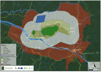
For purposes of conceptualization, planning and communication, the graphics and images presented in this summary cover 6 spatial ‘classes’ or zones: the (1) central, (2) buffer, and (3) transition zone of the Yangambi Biosphere Reserve (YBR, approx. 800 000 ha); an adjacent zone, called the (4) "INERA Concession" (approx. 25,000 ha) and generally considered part of the buffer zone of the YBR; the (5) landscape (“paysage”), and finally (6) the adjacent areas. Throughout the analysis it was apparent that there is a strong interdependence of activities and processes between these ‘classes’.
Over a period of 21 years, it was estimated that approximately 372 383 ha of undisturbed forest was lost to deforestation and/or degradation. This is equivalent to 17 730 ha/year over the entire Yangambi Landscape and adjacent areas. However, since 2017, the disturbance area and associated forest loss has reduced and a gradual increase in regrowth has been observed.
Interesting Links
- Study report summary (FR): /sites/default/files/media/news/Note_LUCC_Paysage_Yangambi_Dec2022_web.pdf
- More information can be found here: Vancutsem, C., et al. (2021). "Long-term (1990-2019) monitoring of forest cover changes in the humid tropics." Science Advances 7(10): eabe1603; doi/10.1126/sciadv.abe1603
- Tracking long-term (1990-2021) deforestation and degradation in tropical moist forests (Forest Resources and Carbon Emissions, IFORCE, EC): https://forobs.jrc.ec.europa.eu/TMF/
